random thoughts on railroad photography, railfanning, technology, and such

Entries in Railfan (26)

Saturday
Oct292011

Union Pacific Leads the Way

So Much For Having a Plan

Last night I settled in to my usual haunt, the easy chair in the front room, and perched upon my lap was my trusty Apple MacBook Pro. I had plans to research and craft a blog post that was long overdue. You see, the Union Pacific Railroad is embarking on a grand tour of the Southwest with one of their treasured and glorious steam engines replete with appropriate carriages of old in tow. The purpose of the event is best left described by a few passages from their press release:

Omaha, Neb., October 10, 2011 – Union Pacific Railroad’s iconic steam locomotive, No. 844, will travel through the Southwestern United States to kick off state centennial celebrations in New Mexico and Arizona, respectively. No. 844 is the last steam locomotive built for Union Pacific and will travel more than 2,900 miles from its base in Wyoming on a 32-day, nine-state tour that will honor the rich railroad heritage of the scenic Southwest.

“Union Pacific long has been a part of the Western United States landscape,” said Scott Moore, vice president of public affairs for Union Pacific’s western region. “It is fitting that No. 844 will be the flag bearer for these centennial celebrations.”

The “New Mexico/Arizona Centennial Tour” begins October 29 when No. 844 departs Cheyenne, Wyo. The train’s consist, which will include passenger cars from Union Pacific’s renowned Heritage Fleet, will stop in each of the following cities before arriving back in Cheyenne November 29…

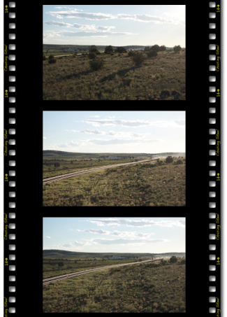
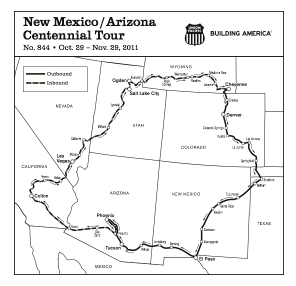
Map of the scheduled route compliments of the Union Pacific Railroad.

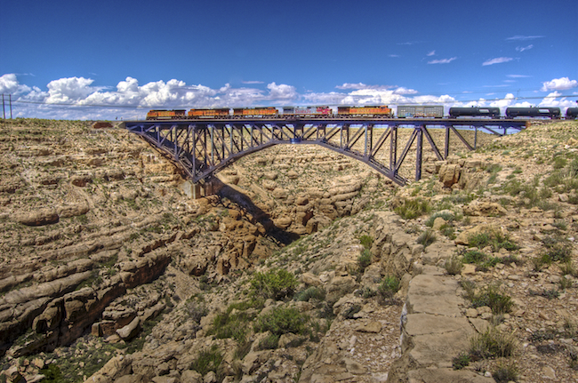
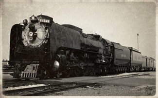
UP No. 844 - Photo courtesy of Union Pacific Railroad.

Obviously this is a big event with a lot of visibility that, over the course of a month, will bring joy and stir the hearts and imagination of many throughout the Southwest. Sure, the UP runs trips like this now and again, but there is something about seeing a steam locomotive, and particularly a large locomotive such as UP Np.844 roaring by at track speed that makes these events special each and every time. Hence, I felt the need to help spread the word about the event and to enlighten the uniformed of the opportunity to chase this train as it makes it way on a circular route through Colorado, Texas, New Mexico, Arizona, California, Nevada, Utah, and finally returning to Wyoming.

The most appropriate place to start, for me, was crafting a colorful map detailing the route and stop-overs. Also, I wanted to mark the locations that I am familiar with that might present some amazing photographic opportunties and help identify good, safe locations for non-fans to see the train up close. I turned to the Union Pacific’s web site to gather details.

While I was reading UP’s material on the subject, and “hitting the links,” I came across a page that, excuse me, gave me the cause to exclaim aloud, “Holy Shit!”  The page is titled “Union Pacific Railroad’s Steam Locomotives Join the App World.”

Now i have praised the Union Pacific in the past, not only for their steam program, but for their prolific use of current technology to inform and entice the general public to become part of the event. It is clearly an excellent marketing strategy that I, as a die-hard railfan, am thankful for. Here is the complete press release from the Union Pacific Railroad:

Union Pacific Railroad’s Steam Locomotives Join the App World

Free UP Steam App Now Available

Omaha, Neb., October 28, 2011 – In the golden age of steam locomotives, trains were tracked using a timetable and a pocket watch. Converging old and new technology, Union Pacific’s legendary steam locomotives now can be tracked with the touch of a screen. The free UP Steam app is available at Apple’s App Store in iTunes for iPhone, iPad and iPod Touch users.

Combining new technology and Union Pacific’s historic steam locomotives, the UP Steam app offers users the chance to keep up with the locomotives on their latest excursions.

App features include:

  • Real-time GPS location of Union Pacific’s steam locomotives.
  • Up-to-the-minute schedules of the latest Union Pacific steam excursion.
  • Notification if Union Pacific steam is scheduled to be within 50 miles of the user’s current location.
  • Photos, videos, descriptions and history of Union Pacific steam locomotives No. 844 and No. 3985.
  • The ability to submit photos taken with an iOS device for inclusion in the Union Pacific Facebook photo album.
  • Real-time Tweets tied to twitter.com/up_steam.
  • The ability to “check in” with the Union Pacific’s steam locomotives using Foursquare.

In addition, the app includes an “About Union Pacific” section describing the company’s operations, shipping information and an overview of the products Union Pacific routinely ships.

As you can glean from the release, it is a rather comprehensive application — offering some great features. Based solely on the description it seems like the application was conceived purposefully to present the technologies that most folks would care about. Now, I say “based solely on…” because I haven’t actually had a thorough oppotunity to test the application. I intend on doing a complete review sometime soon.

So, rather than putting together a traditional blog post about the excursion event, I cracked open a new program for me and used it to craft an homage to the Union Pacific’s effort and desire to put out the app. Hopefully it will serve to inspire and encourage you to try out the app and follow the excursion on your iOS device, along with me. My thought is that application could, and should, serve to enlighten and inform, fans and the general populus alike, about the doings of Union Pacific’s Steam Program.

Chasing Steel’s Homage to Union Pacific’s Steam Program iOS App


Thank you Union Pacific.

Friday
Sep032010

Convergence at Crookton

After leaving the Canyon Diablo bridge we meandered west along Interstate 40 towards Williams, Arizona. By this point it was late afternoon and the lighting was getting good. I was hoping to shoot at a location we discovered during our last trip to this area in 2006. It is a cool spot near Williams that affords a semblance of solitude and the railroad track alignment offers some great curves to accentuate the struggle trains face climbing the Arizona Divide. We dubbed this area “Scary Bear Road” because the area was remote and certainly seemed like bear country to us. (We have “friendly names” for many of our railfanning locations to help differentiate them and make them easier to remember.)

At one point along the way west we discovered that our camper’s refrigerator was not staying cold. I stopped at a truck stop to have a look at it. After opening the rear access paneling and disconnecting the camper’s battery, I saw the potential source of the failure. A 25-amp fuse was not only blown, it was also badly burnt. I went into the store at the truck and tried to find the requisite components to effect a repair. I found only 2 similiar sized fuses - a 20-amp and a 30-amp fuse.

I put the 20-amp fuses in place and reconnected the battery for a test. The fuse didn’t blow but the solder holding the end of the fuse to the glass tube melted and the fuse came apart! Bummer. Not being an electrician myself, I concluded, either rightly or wrongly, that was due to the resistance being generated by the corroded connector on the fuse holder. I used a brass brush to clean the contacts best I could and put in the 30-amp fuse. I tested it again. This time it seem to hold although I was concerned that I had used a bigger fuse than was required.

After running the refrigerator for a good 20 minutes or so to no adverse effect, I put Deb on “Smoke Duty” and asked her to watch the refrigerator access panel in her side mirror for signs of smoke as we headed west on Interstate 40 once again. I put a note on my to do list to stop somewhere and get the right fuse soon.

We eventually reached the official location of “Scary Bear Road,” which is off of Garland Prairie Road, east of Williams. As I rounded the curve and expected to find our turnoff I was sorely disappointed. Apparently in last years since we had been to this area, the US Forest Service had graded a road right through the heart of the “Scary Bear Road” area. Gone was the nondescript single-lane gravel road we knew. It was replaced my a wide and fully-graded dirt road.

We decided to give it a try nonetheless to see if we could locate our previous campsite. As we traveled down the road and tried to correlate our memories with the current surroundings, we were passed by multiple folks on quads or ATVs and many people hauling boats on trailers. It soon became apparent that this area was no longer affording a removed sense of remoteness but rather one of a busy rural route. I did not feel comfortable camping in the area so we, unfortunately, moved on. Well, at least we have our memories of “Scary Bear Road” from 2006.

Route 66 Overpass at Crookton, Arizona.

Disappointed and tired from the day’s event thus far, I decided to by-pass the Williams area entirely and try to reconnect with BNSF’s Seligman Subdivision at the subdivision’s namesake - Seligman, Arizona. Near the beautiful Ash Fork area we found an exit, Crookton Road, Exit 139, which reconnected with Route 66 and, thusly, the tracks. We had been away from the tracks at this point because in 1960, the Atchison, Topeka, & Santa Fe, part of the now BNSF, completed the Crookton-Cutoff which realigned the route between Williams Junction and Crookton, Arizona to reduce grades and curvatures in the area. The old alignment and roadbed can easily be seen from Interstate 40 which has accompanied us along our way since Williams.

Traveling west on Route 66, Crookton Road, from Interstate 40 brought us to location where the Crookton Cutoff crossed under Route 66. As we reached the overpass I slowed, as is my typical style, to look down the tracks in both directions to get see if there are any headlights on the horizon or signals which might betray a pending passing train.

There was no indication of an immediate passing train to be seen, but, being the BNSF’s transcon route, I knew it wouldn’t be long before one was hustling by. As I looked at the trackage from the overpass I was taken by the photographic quality of the location. The left side of the overpass had trackage which curved under the overpass and was baklit by the setting sun. The right side offered a straight alignment which was partly lit by the sun and passed through a cattle range.

I initially continued on passed the location and thought better of my decision. I made a u-turn and then another to reasses the possiblitites. I made up my mind. This was where I was going to make my final stand as the sun set below the horizon.

I found a safe location removed from the passing traffic on the west side of the overpass in which to park and left the engine running so that Deb could continue her present slumber in comfort with the air conditioning running. I grabbed my camera, regretably sans tripod, and made my way back to the overpass. I guess I hadn’t plan to be there long.

As I progressed back down the road I made a few test shots to assess the lighting and possbile framing of the scene. Some cattle were grazing down the embankment and I guess the sight of my long shadow cast down upon them spooked them and they began to run away, “mooing” all the way.

Shortly thereafter, I noticed smoke on the horizon in the west. Here comes one! I checked for traffic on the road and crossed to get into postion. It was an eastbound manifest train moving through West Crookton.

Had I thought to grab my tripod out of the truck I would have tried to capture the scene in HDR. The pace of the moving train would have presented a problem to HDR photogrphy, perhaps, but I have wanted to know what the challenges of photography moving trains in HDR would be so I could possibly figure out how to overcome the problems.

I set-up the camera for aperture-priority and closed the apeture as much as I could. These shots would be hand-held and manually framed. I fired off a series of shots as the train drew near.

Since I have begun to work with HDR photos, it is clearly apparent to me now, how cameras tend to fall short in capturing the scene as I see them. Sure is gives us an essence of what was but the subtle nuances in the details are often washed out and lose relevance in the final shot.

Don’t get me wrong, I like the shots I took and would consider them good, but they don’t do the scene complete justice, in my opinion.

After I got home I played with the images and was able to tonemap some into psuedo-HDR images:

BNSF 4782 West 1 - BNSF 4782 (GE DASH 9-44CW), BNSF 4432 (GE DASH 9-44CW), and 2 more unidentified BNSF GE DASH 9-44CWs are on the point of this eastbound manifest train passing West Crookton, Arizona on BNSF’s transcon as the sun sinks low towards the horizon.
[8/11/2010 - Seligman Subdivision] © 2010 Joe Perry.
BNSF 4782 West 2 - BNSF 4782 (GE DASH 9-44CW), BNSF 4432 (GE DASH 9-44CW), and 2 more unidentified BNSF GE DASH 9-44CWs are on the point of this eastbound manifest train passing West Crookton, Arizona on BNSF’s transcon as the sun sinks low towards the horizon.
[8/11/2010 - Seligman Subdivision] © 2010 Joe Perry.
BNSF 4782 West 3 - BNSF 4782 (GE DASH 9-44CW), BNSF 4432 (GE DASH 9-44CW), and 2 more unidentified BNSF GE DASH 9-44CWs are on the point of this eastbound manifest train passing West Crookton, Arizona on BNSF’s transcon as the sun sinks low towards the horizon.
[8/11/2010 - Seligman Subdivision] © 2010 Joe Perry.

All in all I caught four trains at this location before both, the sunlight and my energy waned. I took a parting shot and thought of the fortune that had brought me here at the right time to get some cool shots despite this was not my intended shooting location.

Sometimes the railfan gods smile upon you, I guess.

Sunset at West Crookton - The sun sinks below the horizon at West Crookton, Arizona.
[8/11/2010 - Seligman Subdivision] © 2010 Joe Perry.

Wednesday
Aug252010

I Finally Met the Devil

The date was August 11, 2010. I awoke earlier than Deb, as is the usual case because she likes to stargaze into the wee morning hours. I was feeling a bit anxious. I knew the day’s activities could be challenging based on all that I read and heard.

I let her sleep in as I made preparations for us to leave the Meteor Crater RV Park where we had stayed the night. We were there to witness the Perseid meteor shower and since we were in northern Arizona we concluded that there was no more appropriate place to see the meteor shower than at Meteor Crater, Arizona, some forty miles east of Flagstaff. 

EBCS West Canyon Diablo - The eastbound control signal at West Canyon Diablo shows a clear indication and flat terrain ahead.
[8/11/2010 - Seligman Subdivision] © 2010 Joe Perry.

Once I packed up all the gear and checked the truck over completely, I awoke Deb and made her breakfast. After we got cleaned up we pulled away from our spot and headed for a rendezvous four years in the making.

The last time we were in this part of Arizona was back in 2006 when Deb and I “chased steel” on the BNSF Seligman Subdivision from Needles, California all the way to Winslow, Arizona. On that trip I was driving a far-less-capable vehicle that would have had issues getting to today’s destination so I opted to defer going there.

In railfanning circles, Canyon Diablo is a coveted and remarkable location. In part due to the fantastic bridge that spans the canyon but also due to the fact that the road to Canyon Diablo is challenging and rugged. I was determined to make the trip this time.

We headed west a few miles on Interstate 40 and eventually took the exit at Two Guns, Exit 230 which is the beginning of the road that leads to the bridge. As the road changed from asphalt near the freeway to a graded dirt road we passed a sign that read “Rough Road Ahead.” I looked at Deb, having previously disclosed the reputation that this road has with her, and asked “You ready for this?” She smiled hesitantly. 

Soon thereafter the road changed composition once again to one of rocks and ruts. Did I say rocks? I meant to say “ROCKS.” I carefully picked my course through the openings and over the ruts best I could. My vehicle weighs in at nearly 11,000 pounds when loaded down with all of our gear and the Lance Camper on the back. It was challenging to say the least.

My main concern was keeping forward momentum as we traveled. Should I stop on a sandy patch of road or desert, I might not be able to get her going again. About 15 minutes into the journey I noticed that the GPS indicated that we still had 2.2 more miles to go to get to the bridge. All I kept thinking about was how am I going to get help if I get stuck. At one crucial point I disclosed my concern to Deb over the road and questioned the value of the effort we had undertaken but it was only fleeting in nature. I pressed on.

We passed more than a few discarded and blown tires along the road. I pressed on. As we neared the bridge and the canyon the GPS became useless. Roads indicated on the GPS’ display simply weren’t there or weren’t there anymore. We had to dead reckon and pick our own way, so to speak.

Despite the challenges of the road and the fact that August is THE rainy month in Arizona, which threw a few “lakes” in our path, we made it to the bridge intact. That is more than I can say for the contents of the camper which were strewn all over the place inside. Oh well, fun, travel and adventure - right?

As we closed on the bridgehead I kept second guessing our location because I had expected to see a bridge. (No duh, uh?) Well, the bridge is almost entirely below the rim of the chasm which, if you are not careful, you could easily drive right into!

Once there I took a celebratory walk and a smoke break to regain my usual calm and collected self. As I meander around I noticed remains of long ago buildings and all things discarded in the course of living. There were old rusted tin cans, glass bottles of yesteryear, and even a grave - well adorned and maintained considering it was from the late 1880s. Wow what a place.

I had known a little history of the area before going there like how the place came to be when the Atlantic & Pacific Railroad were laying rails west out of Albuquerque, New Mexico towards California when the crews ran into the obstacle that is Canyon Diablo. After a failed attempt to build a bridge over the chasm, which occurred because someone misread the plans where the bridge parts were preassembled, the A & P was forced to sell out to the Atchison, Topeka, and Santa Fe Railroad, due to near bankruptcy, which eventually spanned the canyon with a viable bridge in 1882. This was just part of the story. After I returned home I researched the area and the town and learned even more interesting details that I wish I knew when I was there.

Slight Historic Departure

During the time the railroads were waiting for the bridge to be completed the “town” of Canyon Diablo came to be. As with any railhead location, where there are railroad crews there are saloons, prostitutes, and chaos. Canyon Diablo was no different, except in one respect - reputation. Apparently the town of Canyon Diablo had more lawlessness than all of the “wild west” towns that you may be familiar with. Towns like Dodge City, Kansas, and Tombstone, Arizona were peaceful by Canyon Diablo standards. In fact, legend has it that the first sheriff of Canyon Diablo was sworn in at 3:00 PM and buried by 8:00 PM the same day!

I can’t do the complete history of Canyon Diablo justice so I won’t even try. I do strongly encourage those of you who might be interested in learning more to check out this sites which have more information:

As I heard the distinctive low rumble of an approaching freight train, a sound all its own, I raced back to the truck to grab my camera and gear. I proceeded to shoot photos over the next two hours or so, some of which are posted here: 

BNSF 4836 West and The Canyon Diablo Bridge - BNSF 4836 (GE DASH 9-44CW), BNSF 7338 (GE ES44DC), BNSF 4027 (GE DASH 9-44CW), BNSF 651 (GE DASH 9-44CW), and BNSF 4759 (GE DASH 9-44CW) lead their ethanol unit train over the formidable Canyon Diablo east of Flagstaff, AZ.
[8/11/2010 - Seligman Subdivision] © 2010 Joe Perry.

BNSF 7625 West on Canyon Diablo Bridge - BNSF 7625 (GE ES44DC), BNSF 4193 (GE DASH 9-44CW), and BNSF 5233 (GE DASH 9-44CW) are the power for this westbound manifest train seen here crossing the Canyon Diablo Bridge.
[8/11/2010 - Seligman Subdivision] © 2010 Joe Perry.

Westbound Manifest Crosses Canyon Diablo Bridge - A westbound manifest train, BNSF 7625 West, rolls over Canyon Diablo Bridge just east of Flagstaff, AZ.
[8/11/2010 - Seligman Subdivision] © 2010 Joe Perry.

Rusty Barrel at Canyon Diablo - A long forgotten barrel rusts away in the forbidding Arizona weather and sun at Canyon Diablo.
[8/11/2010 - Seligman Subdivision] © 2010 Joe Perry.

Our Rig at Canyon Diablo - Our rig near the bridge over Canyon Diablo. Very little of the bridge extends over the rim of the canyon. The only telltale indications visible from a distance that you are near the canyon and the bridge are the runs of underground fiber cable coming to the surface and braced to span the canyon by those “telephone poles.”
[8/11/2010 - Seligman Subdivision] © 2010 Joe Perry.

Eastbound Intermodal by the Ruins of Canyon Diablo - BNSF 7497 (GE ES44DC), BNSF 7221 (GE ES44DC), and BNSF 5262 (GE DASH 9-44CW) are the lead units of this eastbound intermodal consist as she passes the ruins of an old trading post at Canyon Diablo, AZ. The middle part of the train is currently on the bridge in this shot.
[8/11/2010 - Seligman Subdivision] © 2010 Joe Perry.

BNSF 7497 East - BNSF 7497 (GE ES44DC), BNSF 7221 (GE ES44DC), and BNSF 5262 (GE DASH 9-44CW) are the lead units of this eastbound intermodal consist approaching the eastbound control signals at East Canyon Diablo, AZ under an awesome summer sky.
[8/11/2010 - Seligman Subdivision] © 2010 Joe Perry.

As the clouds began to amass on the horizon I began to become concerned about flash floods and the already difficult road out of here getting more swamped than it already was. We had come and met the devil. I had got some good shots so it was time to go. Best not to tempt the devil…