Our Best Trip Ever - Part 11 - On the Cut-Off
 Joe Perry
(Continued from: Our Best Trip Ever - Part 10 - Heading Into the Unknown)
Day 6 - Part 1
To See an Eagle Nest
Despite my fears of a big cat looking for dinner, we slept well, deep in the heart of Kaibab National Forest. After I awoke and as I made a quick walk around the area where we camped, surveying for animal tracks as much as looking for a good shot, I thought of the today’s plan. We are now fairly far removed from all the trappings of a modern society. “No billboards, no buildings, no graffiti, no power lines — nothing to spoil a scene,” I pondered.
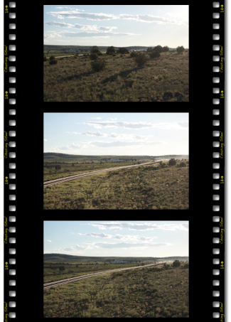
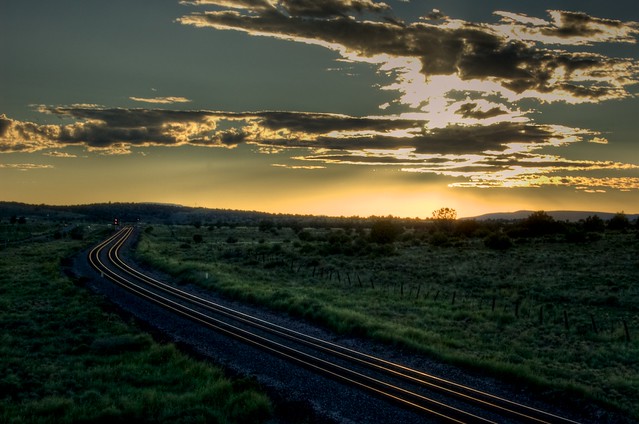
;) The track of our sixth day on the Seligman Sub. The black camera icons indicate the locations that I shot.Today was going to be fun. This is a part of the Seligman Subdivision that I have never visited before so it was going to be an adventure for both Deb and I. It certainly is beautiful in this region of Arizona and not something folks typically think of when they think of Arizona. No sir, no desert here. As I walked back to the truck a westbound intermodal broke the morning silence as it squealed past in a cut below me. As I raised the camera to take a few shots, I was reminded of the challenges of shooting trains in this venue and of what the day might hold:
The track of our sixth day on the Seligman Sub. The black camera icons indicate the locations that I shot.Today was going to be fun. This is a part of the Seligman Subdivision that I have never visited before so it was going to be an adventure for both Deb and I. It certainly is beautiful in this region of Arizona and not something folks typically think of when they think of Arizona. No sir, no desert here. As I walked back to the truck a westbound intermodal broke the morning silence as it squealed past in a cut below me. As I raised the camera to take a few shots, I was reminded of the challenges of shooting trains in this venue and of what the day might hold:
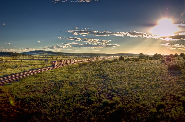
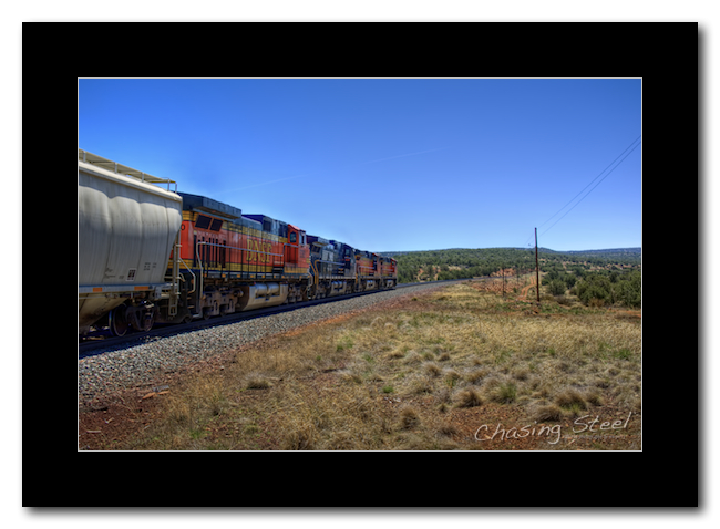
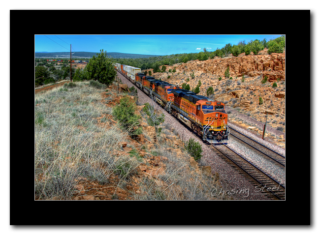
 A Cut-Off Cut - Symbolic of the features of BNSF’s Crookton Cut-Off on the Seligman Subdivision — plenty of massive cuts and fills — this early morning photo shows the challenges of photographing and chasing this segment of the subdivision as a westbound intermodal consist rounds a curve inside of a cut west of CP West DoubleA.
[4/22/2011 - Seligman Subdivision] © Copyright 2011, Joe Perry, ChasingSteel.com.
I went back to the rig and found Deb already making preparations for our departure, so it wasn’t long after my return that we found ourselves on the road heading towards my first target location for the day, Eagle Nest Mountain. I like the name “Eagle Nest Mountain” and it has some pretty compelling photo opportunities as well so it was the prime destination for this part of the trip. I had to size up our options there first and if we spent the whole day there then that would be great.
There wasn’t a direct road between West DoubleA and Eagle Nest, so I back-tracked a bit and opted to take only the best roads. It wasn’t long until we arrived at our destination after a very enjoyable ride. As we entered into the area I could see a massive fill which marked the location I sought. “Wow,” I thought, “that is a huge fill!”
Once track side we made our way around to get the lay of the land. Unfortunately, the forest roads are at a much lower elevation that the railroad grade which precluded me from choosing any spot on the west side of the mountain as I had hoped.
All was not lost though. During the planning phase, I had seen an old quarry site on the eastern slope of the mountain, near the mountain’s peak, which would make for a great campsite if I could reach it. Explaining this all to Deb, I drove towards the eastern side of the mountain, searching for a possible road to the defunct quarry site. Eventually, after I sized up what I saw before me and what showed on the GPS, I picked an old road leading away to the left.
As the grade began to steepen and the road began to narrow, I stopped the truck and put it into “4-wheel drive low.” We then plowed on. After crawling over some rock drifts and a few butt-clinching slopes in the road I began to get excited as it appeared we were almost there. Then my heart sank. Across the road in front of us, which did continue on to the quarry a few yards ahead — and certainly not visible on a satellite map of the area — was a barbed-wire fence with a “no trespassing” sign. Bummer.
Oh well, no quarry campsite for us. However, since we are here and made it this far, not to mention that we needed a break before I attempted a descent, we decided to wait for a couple of trains to go by. Of course, this being the BNSF Transcon, we didn’t have long to wait:
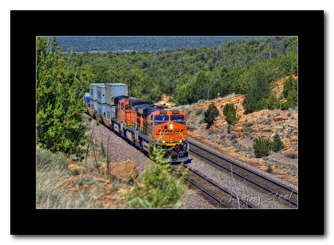
 BNSF 4308 West - BNSF 4308 (GE DASH 9-44CW), BNSF 7908 (GE ES44DC), and BNSF 7308 (GE ES44DC) exit a curve with a westbound intermodal train approaching East Eagle Nest on BNSF’s Seligman Subdivision.
[4/22/2011 - Seligman Subdivision] © Copyright 2011, Joe Perry, ChasingSteel.com.
While Deb was taking in the view and shooting photos from near the truck, I had climbed as far up the slope as I dared — seeing as the elevation was well over 7000’ and I am a cardiac patient! Fortunately it made for a great shot as one of the trains came in from the east with the rig parked where we were stopped. To the left, on the other side of the fence, you can see the start of the quarry site. It would have been a cool spot to camp, no doubt. I plan to return here someday and shoot the sunrise, it should be amazing.
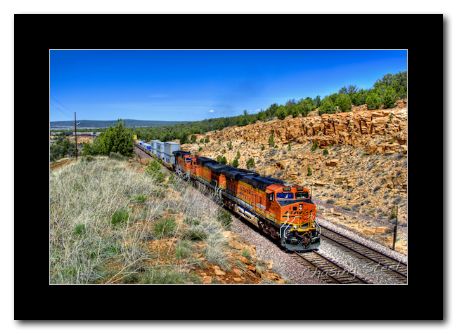
 An Eagle’s View - Perched on the side of Eagle Nest Mountain, this northeastern view shows the passing of a westbound BNSF intermodal train on BNSF’s Seligman Subdivision with BNSF 4308 (GE DASH 9-44CW), BNSF 7908 (GE ES44DC), and BNSF 7308 (GE ES44DC) providing the head end power.
[4/22/2011 - Seligman Subdivision] © Copyright 2011, Joe Perry, ChasingSteel.com.
A Backup Plan
Once we had rested a bit and taken in what Eagle Nest Mountain had to offer us, it was time head back down the mountain and seek opportunities elsewhere. Often it is a bit more difficult going down a trail than coming up one as gravity effects your speed more and my truck is pretty heavy. Also, this time it was complicated by the fact that I had no where to turn around, I was up against the fence. I took a short stroll and surveyed my options. I found a spot where I thought I could muster a three-point turn so we went for it. I backed up to the point and asked Deb to step out of the truck while I attempted the turn. “No sense in both of us tumbling down the hill,” I reasoned. Besides, someone has to take the youtube video of it! Eventually I completed my turn, which was more like a seven-point turn, and we headed down the mountain, a little bummed that we could not spend the day there as we hoped but satisfied we made the effort and got the shots we did.
My secondary location was the curve near milepost 402, a location named Sandstone Tank on the map. It appeared that a short drive on the same road that led us to the quarry road and then we would be there. Oh, contraire.
Once we got back to the main east-west road we made a left turn and reached a cattle fence. After proceeding through the gate, and securing it behind us, we were greeted with a nice meadow sprinkled with some trees about. It was pretty cool. I should have known.
Eventually the scenery gave way to a rather wooded area with some stream beds running through it. Remember, in the previous post, when I mentioned that it appeared as though it had rained in the area recently? Well, a good portion of that rain run-off apparently ended up here. It scattered logs and limbs alike all along the route and gouged good sized channels where there was once mild creek beds. All of this made for a very slow, rough, and tiring ride. It was the Road from Hell. Next to the road to Canyon Diablo, this is bad road number two for us.
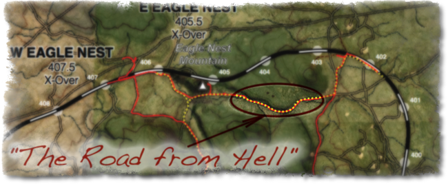 The Road from Hell
They Call It “Sandstone Tank”
Ultimately, hell ended and we were set free as the road mellowed out and merged with one of those well-maintained roads we dreamt of. A quick jaunt north found us track side once again and it looked more promising. I tried to avail myself of one of the few tunnels under the tracks to survey the other side, but, alas, our truck was too tall to fit through. We opted to take a forest road that runs along the south side of the tracks an stopped at a point were the road temporarily roase above the tracks. The spot was killer and we now know it as Sandstone Tank.
It was time for lunch and this where I opted for that foot-long Sonic Coney Dog that I had packed in the fridge from Williams. Hell, today, I earned it. It was every bit as wonderful as I had hoped it would be.
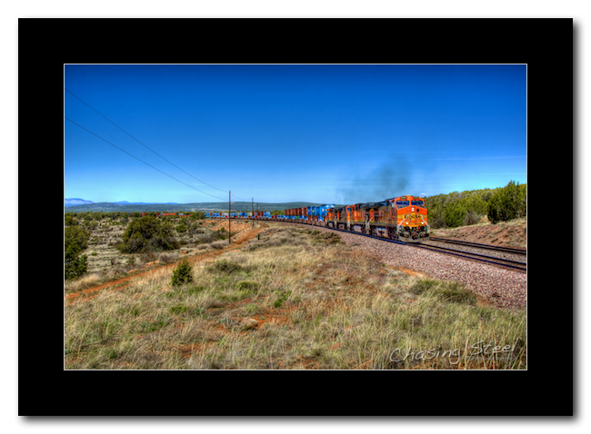
I planned to spend a few hours here, so I grabbed my gear and, using the sun as a guide, walked west to a location to set-up for an eastbound approaching from the west. There was a brief lull in traffic which afforded me the opportunity to just enjoy the view, which I did. The first trains by our location were a couple of westbound intermodals, followed closely by an eastbound one.
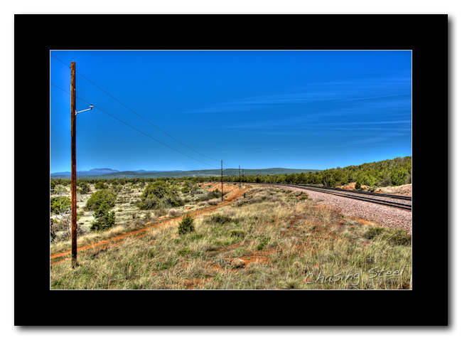 Sandstone Solitude - In a rare quiet moment, sans trains, at a location shown on a map as Sandstone Tank, Arizona, the landscape calls to me.
[4/22/2011 - Seligman Subdivision] © Copyright 2011, Joe Perry, ChasingSteel.com.
;) Waiting for the Shot 2
Waiting for the Shot 2
[4/22/2011 - Seligman Subdivision] © Copyright 2011, Joe Perry, ChasingSteel.com.
 BNSF 5436 East - A quartet of GE DASH 9-44CWs, led by BNSF 5436, climb the grade and negotiates gentle sweeping curves on BNSF’s Seligman Subdivision at Sandstone Tank, Arizona.
[4/22/2011 - Seligman Subdivision] © Copyright 2011, Joe Perry, ChasingSteel.com.
As the day wore on, it began to seem as though the trains, one eastbound and one westbound, always seemed to meet each other at our location. More often than not we had two trains in view at one time. Here’s an example of two intermodals blowing by one other:
;) Passing Trains
Passing Trains
[4/22/2011 - Seligman Subdivision] © Copyright 2011, Joe Perry, ChasingSteel.com.
Sandstone Tank has many options for setting up. Here I walked east of the rise and got a tight shot showing the diesels working hard upgrade and a slide fence that warns trains of fallen rocks inside a cut:
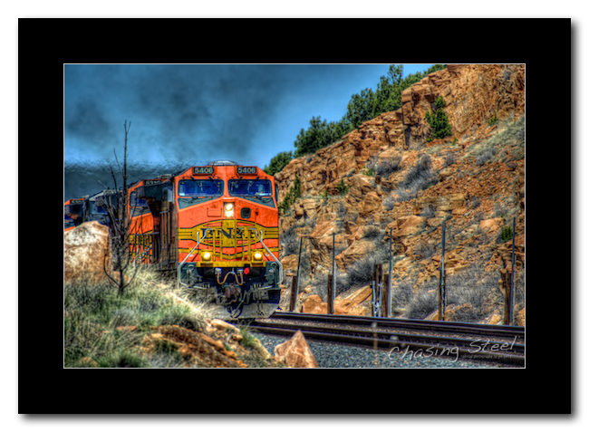 BNSF 5406 East 1 - BNSF 5406 (GE DASH 9-44CW), BNSF 5216 (GE DASH 9-44CW), NS 9845 (DASH 9-40CW), and BNSF 5380 (GE DASH 9-44CW) enters a cut that is protected by slide fence near Sandstone Tank, Arizona on BNSF’s Seligman Subdivision.
[4/22/2011 - Seligman Subdivision] © Copyright 2011, Joe Perry, ChasingSteel.com.
Here is the view to the east of the rise, pretty killer:
 BNSF 5406 East 2 - BNSF 5406 (GE DASH 9-44CW), BNSF 5216 (GE DASH 9-44CW), NS 9845 (DASH 9-40CW), and BNSF 5380 (GE DASH 9-44CW) lean into a gentle curve near Sandstone Tank, Arizona with a manifest consist in tow on BNSF’s Seligman Subdivision.
[4/22/2011 - Seligman Subdivision] © Copyright 2011, Joe Perry, ChasingSteel.com.
And a few taken from atop the rise itself:
 BNSF 7279 East 1 - BNSF 7279 (GE ES44DC), BNSF 5045 (GE DASH 9-44CW), and BNSF 7504 (GE ES44DC), are up front on this eastbound intermodal train near Sandstone Tank, Arizona on BNSF’s Seligman Subdivision.
[4/22/2011 - Seligman Subdivision] © Copyright 2011, Joe Perry, ChasingSteel.com.
 BNSF 7279 East 2 - BNSF 7279 (GE ES44DC), BNSF 5045 (GE DASH 9-44CW), and BNSF 7504 (GE ES44DC), are up front on this eastbound intermodal train near Sandstone Tank, Arizona on BNSF’s Seligman Subdivision.
[4/22/2011 - Seligman Subdivision] © Copyright 2011, Joe Perry, ChasingSteel.com.
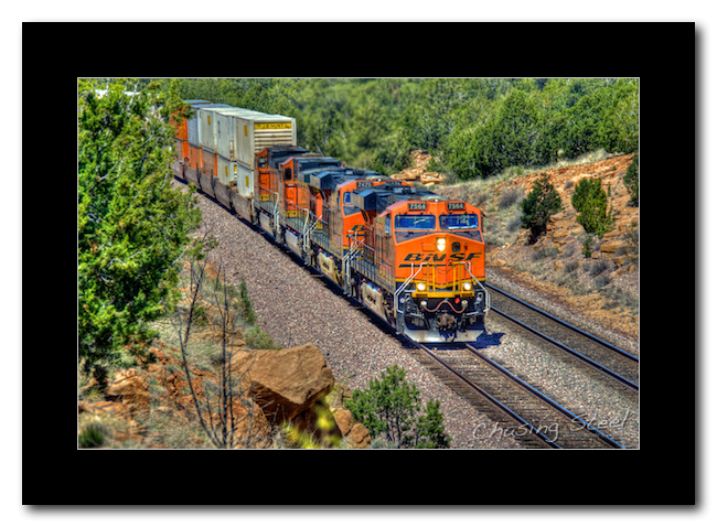 BNSF 7564 East 1 - BNSF 7564 (GE ES44DC), BNSF 7475 (GE ES44DC), BNSF 4330 (GE DASH 9-44CW), and BNSF 4175 (GE DASH 9-44CW) lead this eastbound intermodal train near Sandstone Tank, Arizona on BNSF’s Seligman Subdivision.
[4/22/2011 - Seligman Subdivision] © Copyright 2011, Joe Perry, ChasingSteel.com.
 BNSF 7564 East 2 - BNSF 7564 (GE ES44DC), BNSF 7475 (GE ES44DC), BNSF 4330 (GE DASH 9-44CW), and BNSF 4175 (GE DASH 9-44CW) lead this eastbound intermodal train near Sandstone Tank, Arizona on BNSF’s Seligman Subdivision.
[4/22/2011 - Seligman Subdivision] © Copyright 2011, Joe Perry, ChasingSteel.com.
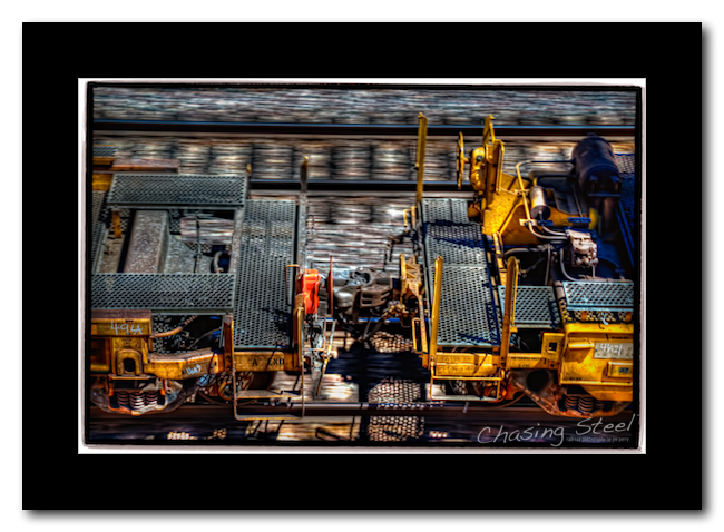 “A” End
[4/22/2011 - Seligman Subdivision] © Copyright 2011, Joe Perry, ChasingSteel.com.
Back to the ‘Nest
After garnering nearly 500 photos from the “tank,” I wanted to try another location. I really wanted to get some shots around Eagle Nest is how I sold it to Deb. The truth is that I planned another special side trip for her and this was the perfect time to take her there. We are both big fans of things from America’s past, especially the Old West.
So we headed back to the ‘Nest, but not, I repeat NOT the way we came. Instead we took the “big roads,” a longer but more much enjoyable ride. Upon our arrival I sought out the tunnel that afforded us an opportunity to cross the tracks and head a bit north. Fortunately our vehicle was not taller than the tunnel in this case and we made it under the tracks just fine.
Once on the other side it took a bit of work to find our quarry but we eventually did. The location we sought was where the Beale Wagon Road traversed the area. This is a wagon road from the mid 1800’s that ran east-west across New Mexico and Arizona to California. This road is noted for using camels during it’s construction and was laid out by Navy Lieutenant, Edward Fitzgerald Beale under contract with the U.S. Government.
From Wikipedia article:
Of this road, Beale wrote: “… It is the shortest (route) from our western frontier by 300 miles, being nearly directly west. It is the most level, our wagons only double-teaming once in the entire distance, and that at a short hill, and over a surface heretofore unbroken by wheels or trail on any kind. It is well-watered! Our greatest distance without water at any time being twenty miles … It crosses the great desert (which must be crossed by any road to California) at its narrowest point.”
Consequently, Beale’s route and survey served as the basis for the Atchison, Topeka, and Santa Fe Railroad as well as U.S. Interstate 40 across this portion of the country.
Back to Town
Not having found a suitable camping location that I felt comfortable with and one with a view of the tracks that didn’t require a strenuous hike, and having visited the Beale Road, we decided to head back to town, so to speak. As we headed south on the “big road” I stopped and waited to get a shot of a train crossing the bill fill adjacent to Eagle Nest Mountain for prosperity sake:
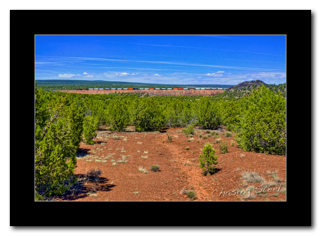 The Big Fill - In Arizona, on BNSF’s Seligman Subdivision, a westbound intermodal train leaves CP East Eagle Nest via a massive fill heading towards CP West Eagle Nest. Part of Eagle Nest Mountain can be seen on the right.
[4/22/2011 - Seligman Subdivision] © Copyright 2011, Joe Perry, ChasingSteel.com.
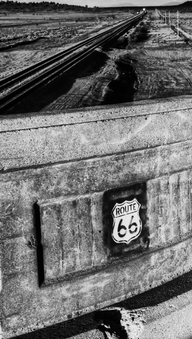
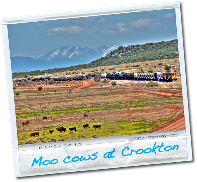
We reached I-40 and headed west. After a brief run at 70 MPH, enough to throw most of the rocks from our treads and with apologies to my fellow travelers at the time, we exited and headed towards one of favorite spots along this portion of the subdivision, Crookton, the namesake for the cut-off.
Once we reached the old Route 66 bridge over the BNSF trackage I pulled off of the highway and waited for a train to arrive so I could shoot a panorama shot of the location looking north in this case:
;) Crookton Panorama
Crookton Panorama
[4/22/2011 - Seligman Subdivision] © Copyright 2011, Joe Perry, ChasingSteel.com.
Click image for larger size.(5MB)
 [4/22/2011 - Seligman Subdivision] © Copyright 2011, Debra Parra, ChasingSteel.com.
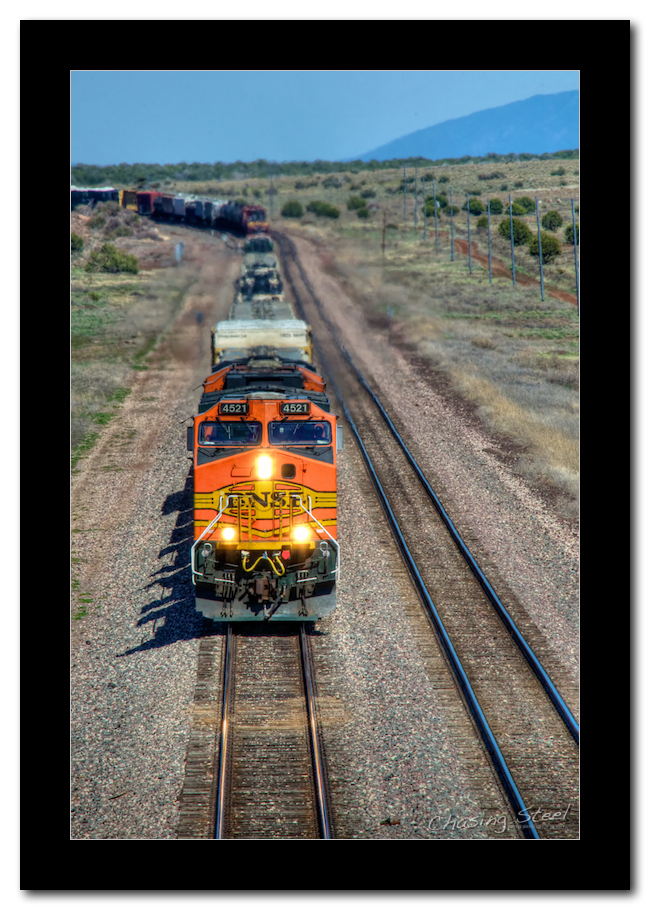 BNSF 4521 West - BNSF 4521 (GE DASH 9-44CW) is the lead unit on this westbound manifest train approaching the old “Route 66” overpass near Crookton, Arizona.
[4/22/2011 - Seligman Subdivision] © Copyright 2011, Joe Perry, ChasingSteel.com.
It was time to take a break and secure a lodging location for the evening at this point so we headed towards Seligman, a short distance away. I’ll save that for the next post…