random thoughts on railroad photography, railfanning, technology, and such

Entries in Railfanning Trip (20)

Monday
Jun212010

The Memorial Day Weekend Mega Tour - Part 4

(Continued from: The Memorial Day Weekend Mega Tour - Part 3)

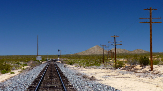
You have to admit that I gave the Cima Subdivision a good effort. I just wasn’t having any luck. Sometimes the railfan gods just don’t smile upon you. That’s what a backup plan is for. Mine was to head south into Amboy and my home away from home, BNSF’s Needles Subdivision.

I made my way back down that arduous road that I had just traveled down a mere two hours ago and reached the pavement of the Kelso Cima Road once more. I kept an eye on the signals and trackage in case my luck would change as I motored south towards the Kelso depot and Kelbaker Road. My thought was that now that I was committed to leaving the Cima Subdivision the railfan gods would throw me a bone. 

Well, they did and then showed me who was boss again. As I reached the Kelso depot I saw the nearly forgotten vision of a headlight on the horizon. Could it be? I jumped out of my rig and positioned myself near the grade crossing on Kelbaker Road so I could spy the signal indications. “Sure enough, one’s coming,” I exclaimed to myself in an embarrassing sort of way. Jeez, I felt like a foamer!

As she neared, I framed the shot. The train was back-lit so I would get the best shot when she passed me and blew by the depot. I leveled the tripod and fussed with settings as I hurried to get “the shot.”

“Damn she’s not going very fast,” I noted. Well that was good for me as it gave me time to reposition for a better shot. OK, now I am ready. Looking over my shoulder, I was filled with disappointment once again. She came to a stop, well short of the depot and my location. “Shit!” Now I felt like I was being toyed with.

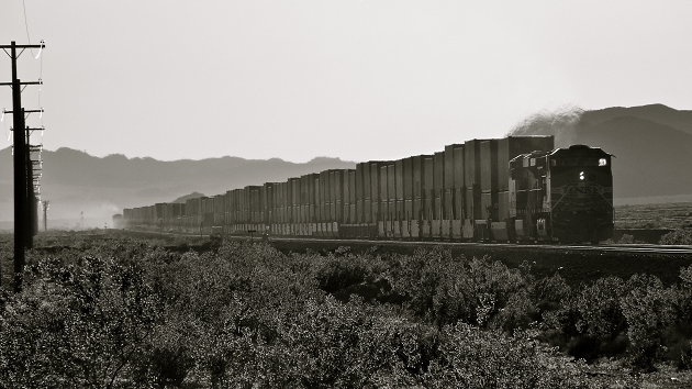
Here is the only shot of the train, any train, that I was able to capture while on the Cima Subdivision inside the Mojave National Preserve boundaries for a total 7 hours or so:

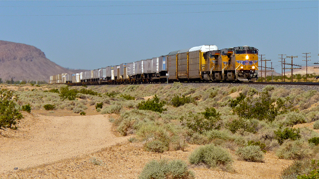
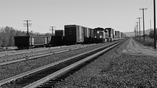
UP 7785 East at Kelso, CA - UP 7785 (GE C45ACCTE) slows to stop at Kelso, CA with an eastbound intermodal train. In a rare scene these days of distributed power, the train will wait here for a helper locomotive to assist with it’s assault of the Cima grade. [5/29/2010 - Cima Subdivision]I bid farwell to Kelso, the Cima Subdivision, and the Mojave National Preserve as I bolted south on Kelbaker Road towards Interstate 40. I smiled at my huge misfortune thus far as I cranked up the tunes and rolled the windows down.

As I made my hand into an airplane and held it out the window in a flying gesture, as all boys do, I thought of the goodness that the Needles Subdivision would bring. I smiled and laughed aloud. Things were looking up already.

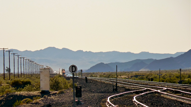
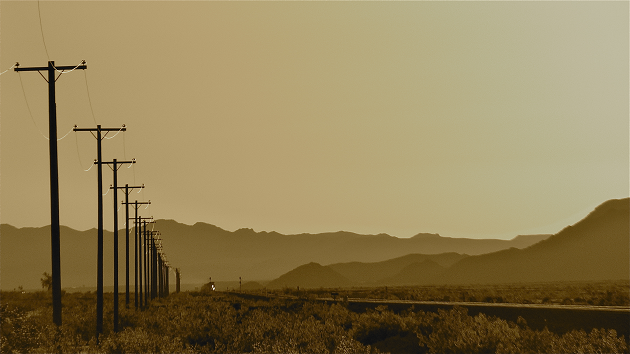
I passed Interstate 40 and continued south on Kelbaker Road at a decent clip. I could sense the light would soon be low in the sky, one of my favorite times to shoot photographs. As I crested the the top of the last grade that leads down to the National Trails Highway, I saw no less than three trains off in the distance! Salvation at last!

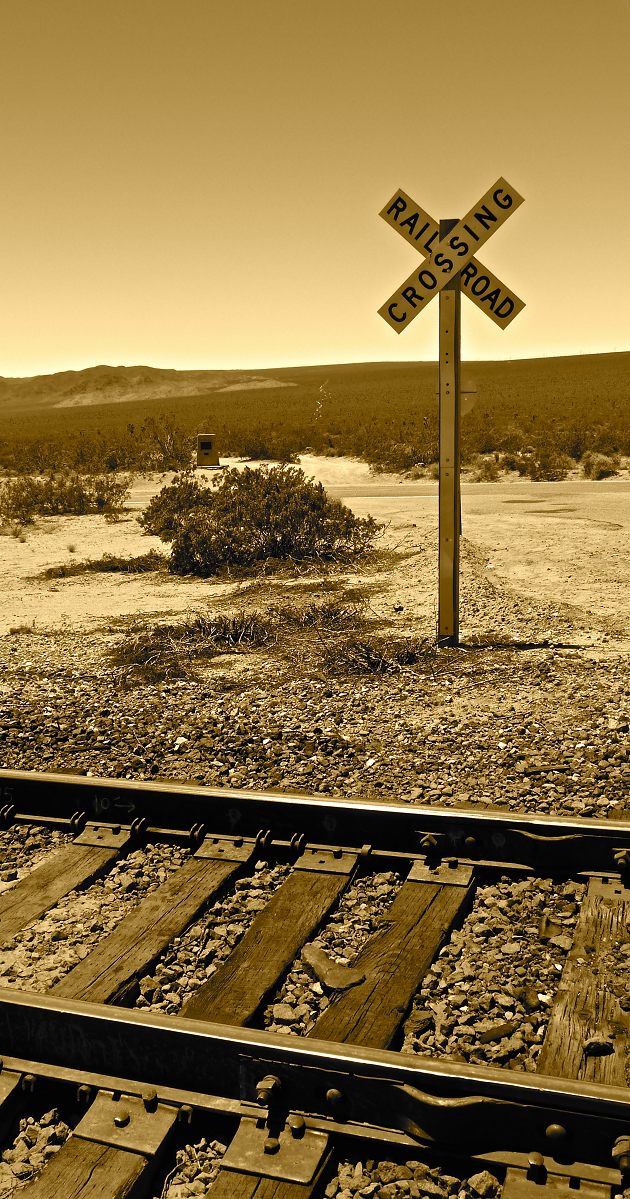
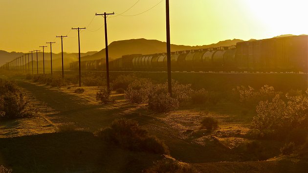
I eventually reached the grade crossing at Amboy in time to catch an eastbound that had just cleared Bagdad. I hurried across the crossing on foot and set-up for the shot. I felt the rush of being “back in the action” as she scooted by at track speed.

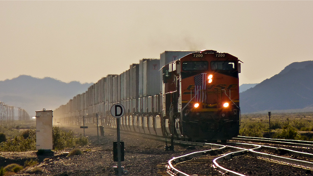
I suspect that most photographers will agree that when you are shooting you are focused on getting the shot and not necessarily the subject of the shot. After this train went by and I reviewed the shots I realized that she was a beauty - an even-numbered lead unit an sporting an American flag to boot. The BNSF’s Needles Subdivision welcomed me in a huge way, and I think I earned it: 

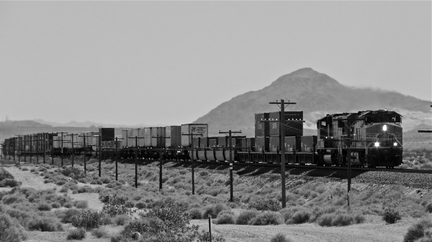
Distant Thunder - As the sun begins sinks low into the sky, BNSF 7200 (GE ES44DC) is fully in charge of this eastbound stack train as she nears Amboy, CA. [5/29/2010 - Needles Subdivision]

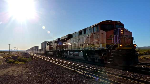
BNSF 7200 East - Late in the day, BNSF 7200 (GE ES44DC) and her intermodal charge kicks up dust as she proceeds east at track speed (70 MPH) through Amboy, CA. [5/29/2010 - Needles Subdivision]

A Patriotic Tribute - As the suns backlights the scene, the crew of BNSF 7200 (GE ES44DC) East has apparently adorned the nose of the locomotive with a US flag as a tribute to Memorial Day, seen here blowing through Amboy, CA. [5/29/2010 - Needles Subdivision]

I stayed throughout sunset in the area just west of Amboy and took as many shots as I could:

BNSF 6621 West 3 - BNSF 6621 (GE ES44DC), BNSF 5048 (GE DASH9-44CW), and BNSF 5068 (GE DASH9-44CW) lead this westbound intermodal by Amboy, CA with two distibuted power units on the rear. [5/29/2010 - Needles Subdivision]

BNSF 7433 East - BNSF 7433 (GE ES44DC) is on the point of this eastbound intermodal approaching Amboy, CA as the sun begins to set. [5/29/2010 - Needles Subdivision

Sunset Desert Railroading - In the golden hours of twilight, the sun traces the shape of this westbound manifest train as she heads west towards Barstow, CA after passing an eastbound intermodal at Amboy, CA. [5/29/2010 - Needles Subdivision]

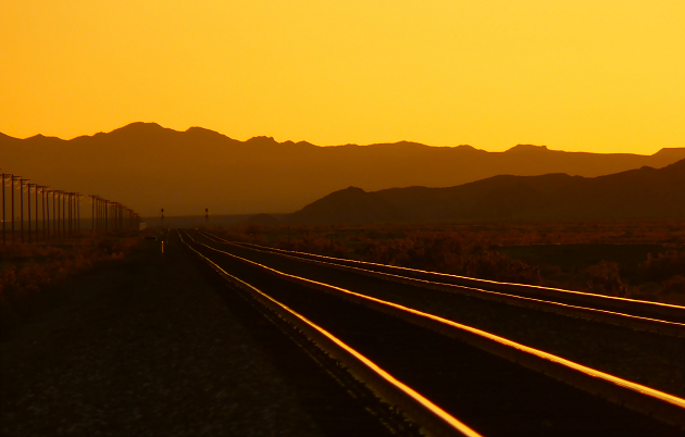
The Calm - A lull in traffic complements the sunset nicely near Amboy, CA. [5/29/2010 - Needles Subdivision]At this point I received a call from Deb saying that she was off to Las Vegas as a treat for her Mom. Although I was already in the Ludlow region seeking a good spot to camp for the night, I decided to head home to dog sit will Deb was gone.

So I left the Needles Subdivision as well and got home around 10:00 PM, a mere 19 hours after I had left and I had driven many, many miles. I was tired and had been intensely challenged yet I feel that captured some great scenes. Nonetheless, I had a great time.

By the way, there are still two days left in the weekend…and the Mega Tour…

Saturday
Jun192010

The Memorial Day Weekend Mega Tour - Part 3

(Continued from: The Memorial Day Weekend Mega Tour - Part 2)

After stopping in at the Kelso Depot Visitor’s Center of the Mojave National Preserve and talking with the ranger, I had to devise a new plan. I wouldn’t be able to follow the Cima Subdivision’s trackage, nor camp along the route, as I had hoped to do.

I was still permitted to follow the trackage from Kelso to Cima, California via the Kelso Cima Road so, that coupled with the knowledge of a possible camp site relatively close to Cima, that the ranger told me about, gave me enough incentive to continue with my plans - albeit modified extensively.

I drove north towards Cima at a leisurely pace to enjoy the beautiful scenery and to get a idea appreciation of the lay of the land in hopes of identifying good photo locations. There were plenty of great views and vistas along the way - just no trains. “Perhaps they are a little further up the line,” I thought as I kept driving, knowing all the while that I was lying to myself.

I happened upon a control point (or siding) named CP Chase, which is the name of one of our puppies, and decided to wait for a train there. I took a few shots to make sure the camera settings and my framing of the subject were good. Here is one of the photos that I took so you can get a sense of the terrain and track structure:

CP Chase - UP trackage at Chase, CA in the Mojave National Preserve. [5/29/2010 - Cima Subdivision]

As the temperature rose, I realized that I had been on the road for nearly 12 hours at this point and I began to feel weary. As I sat at the crossing at Cedar Canyon Road, taking a bit of a rest, I looked out the windshield and studied the terrain. Off in the distance, running in a due westerly direction, was a faint line marking an obvious trail of some sort.

After considering my location and my knowledge of the area, I surmised that I was looking at the famous Mojave Road, used by many to access California at the coast. It was initially a route for the local Mohave Indians to hunt and trade along. It wasn’t until after I snapped this photo of the scene that I noticed the marker near the trail-head confirming my discovery (Remember I said I was tired!):

Traveling Through Time - Three arteries of travel, from ancient times through today, comprise this scene in the Mojave National Preserve. In the foreground is Union Pacific’s Cima Subdivision, in the middle of the frame is the Kelso Cima Road and in the distance is the ancient Mojave Road which was used by Mohave Indians to reach the California coast. [5/29/2010 - Cima Subdivision]

After waiting nearly an hour I decided it best to try to find a train rather than waiting for one to find me. I bid farwell to CP Chase and raced toward Cima, about 10 miles north on Kelso Cima Road. I made the trek in short order and remembered quickly why I was fond of this area so much. 

In my opinion, the area around Cima holds tons of photographic opportunties, with repsect to railroad photography. The are all of the requisite elements of grade, curvature, diversity, and beautiful scenery. The only thing missing, at the time I was there, were the TRAINS!

I began to sense a pattern. I would find a great location to shoot a train from and wait - but no trains would grace the scene for me. I know that the Cima Subdivision has lower traffic volumes than most of the other subdivisions that I chase, but this was down right sad.

I decided to seek out the camp site the ranger had told me about and set-up camp in hopes of a better tomorrow. I departed Cima, and all of the missed opportunites, heading south towards CP Chase. A short distance down the road and I had reached the turnoff for the camp site. 

Of of the disadvantages of carrying a “cozy condo” with you, wherever you go, is that your opportunities to turn around are reduced due to the vehicle’s size and weight. So was the case on this road. I had traveled further and further down this road to a point where I began to realize it might take some time to get there and, more importantly, leave there in the cover of darkness tomorrow morning. I had second thoughts about the appropriateness of the “secret camp site” for this particular trip. I looked for a place were I could safely turn around. There was none, as the following photo shows, and I was now committed to the find the camp site:

Road to the “Secret Camp Site” - This is the a photograph of the road that led me to the secret camp site described by the ranger. This was the mellowest part of the eight mile trek to the end of the road.

After a good hour’s drive I reached the camp site and could see why the ranger considered it one of the best in the park. The area was beautiful and remained predominately untouched by man. I found myself tucked into a draw, surrounded on three sides by mountains. The area was ablaze with blooming cactus and foliage of all sorts. It was insanely quiet.

I decided to make the most of it since I was here. I parked the truck and got something to eat. After lunch I decided to take a few a “nature” photos since I was miles away from the tracks by now. Here are two of the many shots I took of the local blooms: 

Mohave Pricklypear Cactus Bloom - The beautiful yellow bloom of the Mohave Pricklypear Cactus (Opuntia erinacea).

Strawberry Hedgehog Cactus Bloom - A gorgeous Strawberry Hedgehog Cactus flower (Echinocereus engelmannii).

I walked around, being mindful of the ranger’s last words regarding the “abundance” of snakes in the area, and took photos for about one hour when I thought I would rest up a bit in the camper. On my way to camper I saw a previously unseen, large anthill near the camper with the largest black ants I have ever seen! Unfortunately, the ants were heading out in a line straight for my camper! Enough was enough I decided to leave the fun and frivolity of the Mojave National Preserve and the Cima Subdivision behind me…

Thursday
Jun172010

The Memorial Day Weekend Mega Tour - Part 2

(Continued from: The Memorial Day Weekend Mega Tour - Part 1)

With the high traffic level I encountered at Daggett in short order, I drove north on the Daggett-Yermo Road towards Yermo hoping that the Cima Subdivision provided ample traffic and photo opportunities. I had already seen two eastbound Union Pacific trains return to home rails and head off towards Yermo and I was in pursuit.

I had planned to follow the tracks via Yermo Road which roughly parallels the Cima Subdivision for the first sixteen miles north out of Yermo. I reached one of the few grade crossings on Yermo Road that I used to get on the sunlit side of tracks and wait for a train out of, or inbound to, Yermo. I set-up at Minneola Road at caught this eastbound intermodal after a short wait:

UP 7660 East at Minneola Road - UP 7660 (GE C45ACCTE), UP 7371 (GE C45ACCTE), and UP 4984 (EMD SD70M) are on the move again after a brief stop at Yermo, CA with this eastbound intermodal consist, seen here at Minneola Road. [5/29/2010 - Cima Subdivision]

By listening to the railroad’s radio traffic I gleaned that there was a westbound a dozen miles or so east of Minneola Road so I continued east. As I closed the distance and continued to listen to the railroad’s road channel, the picture became clear that the westbound train “in the hole” waiting to meet the eastbound that I had just photographed. Since the Cima Subdivision is single tracked, trains need to pass or meet other trains at locations designed for this purpose, called sidings.

I didn’t make it in time to see the meet. The crew of the westbound performed a “roll-by” inspection of the eastbound train as it passed the siding. The crew identified, and subsequently informed the other train via radio, that one of the containers the train was carrying appeared to be have been broken into.

It turns out that this is a big problem for the railroads, particularly in the more remote locations of the desert. This served to remind be to keep an eye open for riders and, more importantly, be careful of other folks that I might encounter track side because these criminals have been known to carry guns as well.

I did manage to capture the westbound as she meet me at the detector located at milepost 175.3:

UP 7631 West - UP 7631 (GE C45ACCTE) and UP 3991 (EMD SD70M) approach the hotbox detector at MP 175.3, near Manix, CA, with a westbound intermodal train. [5/29/2010 - Cima Subdivision] 

As the westbound hustled towards Yermo, I continued east on Yermo Road to another grade crossing opportunity at Alvord Mountain Road. Once I got to the intersection I saw the road blocks on Yermo Road preventing further use of Yermo Road east of the intersection for some reason. It became apparent that I would not be able to run along the tracks any further from Yermo Road so I decided to take a break on the south side of the tracks on Alvord Mountain Road.

I parked the truck in the shade of a small tree adjacent to the grade crossing and rested a bit in hopes of catching another passing train while I was on the “sunny side” of the tracks. After about a fifteen to twenty minute wait, with no radio chatter from detectors or crews, I decided to keep moving east.

I pulled the truck up to the grade crossing and slowed to get one last look at the signals for an indication that something was “lined” my way when I saw a white vehicle kicking up a serious dust cloud on the railroad access road headed towards me. 

Not wanting to sit on the crossing, but still curious as to who or what the white vehicle quickly approaching was, I parked on Yermo Road. I thought perhaps it might be a signal maintainer or other MOW crew.

The vehicle finally got to the grade crossing an although it remained on the south side of the tracks, it stopped near where I parked. I couldn’t quite make out the details of the sign that adorned the vehicle’s door but I could tell that it was either a Union Pacific Railroad Police officer or a “contract security firm” hired out by the Union Pacific.  Either way I garnered a long and curious stare from the single occupant of the vehicle.

I assumed that he might not be able to see who I was clearly so I decided to exit my vehicle and stand there in case he wanted to approach me and ascertain my intent for being in the area. Maybe this was sufficient enough for him to conclude that I was harmless because he promptly continued east on the access road after I exited my vehicle. Perhaps he thought I might have been connected with the break- in of that eastbound intermodal train - who knows.

Since I was forced to take Interstate 15 north to continue my trip I thought I would exit at the next opportunity and double back south down Yermo Road to continue my track side chase. The exit that I choose was Field Road. Here I made an immediate right turn onto Yermo Road and discovered two California Highway Patrol vehicle parked with the officers chatting and a permanent “Road Closed” sign and blockade behind them. Bummer, it was obvious that I would not be able to access that region of the Cima Subdivision without trespassing or using the railroad’s service road - something I was not willing to do. I got back on Interstate 15 and continued northeast.

I did plan to bypass the most picturesque region of the Cima Sub, Afton Canyon, which lay a few miles north of the Field Road exit because I was a solo vehicle weighing nearly 11,000 pounds. I did not want to bury the truck in the sand and not have a buddy close by to pull me out so I continued on to Baker, California.

After a pit stop in Baker for food and fuel, I turned onto Kelbaker Road which would take me into the heart of the Mojave National Preserve and facilitate my return to the tracks of the Cima Sub.

After about a 45-minute drive I arrived at Kelso, California and the beautifully-restored, former Union Pacific passenger depot which is now a Visitor’s Center for the National Park Service. I pulled into the parking lot, gathered my materials, and made a beeline for the depot to get some relief from the heat and talk to a ranger about my plans. It was a good thing I did.

Using the park map which was on top of the Information Desk counter, I outlined my plan for one of the rangers there. He promptly advised me that my planned route would take my onto Union Pacific’s private property because the shown road on the map was actually a railroad access road and not a Park Service road. He did advise me that I could take a parallel route over Powerline Road but it was one to two miles away from the tracks - certainly not ideal. “Bummer,” I thought.

I then asked about camping along Powerline Road and he proceeded to recite the Park rules and regulations governing camping inside the Park. Basically “roadside camping,” as he referred to it, is only allowed at selected preexisting sites and none of them where were I had hoped they would be in relation to the tracks. “Bummer,” I thought, once again.

At this point, I suspect due to a sense of pity on me, the ranger divulged the location of a little-known campsite near Cima that he thought might best suit me and my desires. We chatted about accessibility due to my truck’s size and weight. He asked if I had 4-wheel drive to which I said “yes.” I then explained about the 11,000 pounds of my truck’s weight and the difficulty that presents in sand. He said “it shouldn’t be too bad.” “Great,” I thought to myself,  “what’s that mean?” 

I turned for the door as I thanked him for his time and insight and especially the suggestion of the “secret” campsite. “Oh, one more thing” he added. “The rattlesnakes are out in abundance.” “Great,” I thought to myself. I knew what that meant…