PROMONTORY: The Hallowed Ground of America's Western Railroad History
The Big Trip - Day 4
We were awaken by the sound of a tractor and metal slamming against metal. I stepped outside the camper and found the source of the noise. Apparently it was watering day at the Brigham City/Perry South KOA and there was a grounds man laying massive 3-inch pipes on the grassy common areas of the campground. I don’t recall the time exactly but it was too early, in my opinion, to awaken any guests so rudely. Score another point for the Perry KOA!
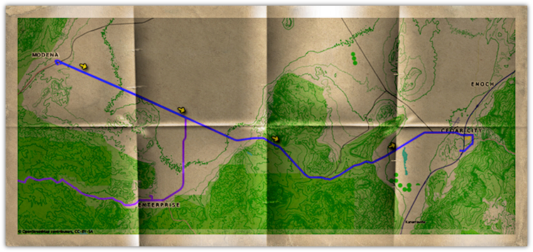
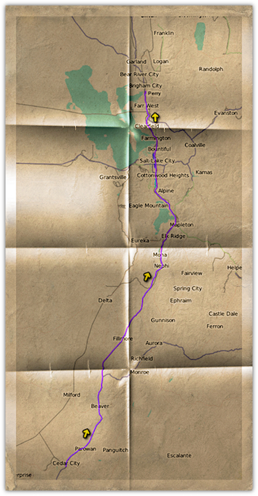
Despite the start to our morning, today was going to be a great day because we were headed to one of my favorite locations — the Golden Spike National Historic Site at Promontory, Utah. We got cleaned up and broke camp. We planned on spending the night on public land somewhere near the Golden Spike National Historic Site so we made certain to empty our waste tanks and fill the fresh water tank.
As we made the rather pleasant drive towards Promontory, I fortunately looked down at the fuel gauge on the truck and realized, in my haste to get to the park, I had forgot to get fuel! We were about one-third of the way to Promontory at this point and I knew there were no gas stations along the way due to remoteness of the site. We turned around and headed back towards Brigham City to top off.
Golden Spike National Historic Site
After some thirty miles of traveling west out of Brigham City we reached the entrance to the Golden Spike National Historic Site.
What is this Place?
On May 10, 1869, the Union Pacific Railroad and the Central Pacific Railroad joined their rails here at Promontory Summit, Utah Territory and realized the dream of an entire nation—a transcontinental railroad across America.
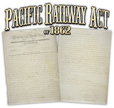 Citation: Pacific Railway Act, July 1, 1862; Enrolled Acts and Resolutions of Congress, 1789-1996; Record Group 11; General Records of the United States Government; National Archives.This dream, which became known as the “Pacific Railroad,” had its roots in the early 1830s and soon garnered a lot of support from the likes of Asa Whitney, Zadock Pratt, Theodore Judah, The Big Four—Leland Stanford, Collis P. Huntington, Mark Hopkins, Charles Crocker, and most importantly, President Abraham Lincoln.
Eventually, after much debate in Congress, the dream became official when President Lincoln signed the Pacific Railway Act of 1862 on July 1 of that year. This act not only formed the Union Pacific Railroad, which would build west from the Missouri River, but and also named the Central Pacific Railroad, which would build east from Sacramento, California as the two railroads which would receive federal land grants and funding to build a railroad the likes of which the world has never seen.
The story of the Pacific Railroad is a fascinating one. It is truly a microcosm of America’s story. It is a story of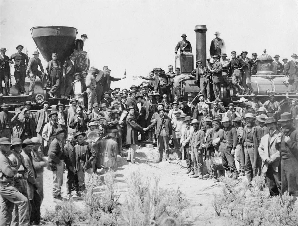 Andrew J. Russell’s “East and West Shaking Hands at Laying of Last Rail.” - May 10, 1869.
Utah State Quarter depicting the Golden Spike Ceremony - Released: November 5, 2007 vision and determination, greed and scandal, ingenuity and back-breaking labor. It is a story that spans American culture from emigrants, both Chinese and Irish, all the way to the elite of the Supreme Court of the United States. It is the story of you and I.
Seven years later the transcontinental railroad would be complete and joined at Promontory, Utah.
Those of you not familiar with the history of the Pacific Railroad, nor Promontory and the Golden Spike NHS, might still recognize this famous A.J. Russell photograph of the “golden spike” ceremony from a history class or two. Perhaps you have seen the back side of the U.S. quarter for Utah which depicts this event and location nicely.
Promontory Today
Much of the original transcontinetal route is still used today as part of the Union Pacific Railroad system which now includes the original Central Pacific Railroad (Southern Pacific Railroad) as well. Fortunately, this important and historically signigficant part of the route was bypassed in 1902-04 by the building of the Lucin Cutoff by the Southern Pacific Railroad which had obtained a lease to the Central Pacific Railroad in 1885 and official acquiring it in 1959. This bypass eventually left the route up for abandonment and scrapping during World War II. The National Park Service now owns the old railroad right-of-way and the surrounding grades which constitutes the Golden Spike National Historic Site housing a Visitor’s Center, a few miles of trackage, an engine house and assorted historical assets. For details click on the Park Tour Map below:
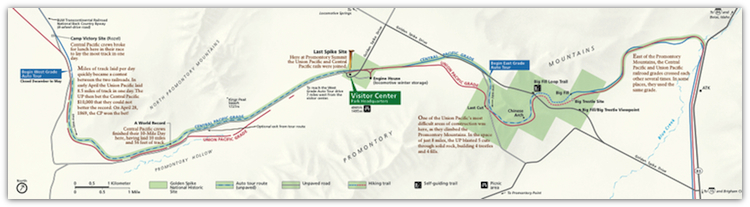 Park Tour Map - Golden Spike National Historic Site
Courtesy of National Park Service, U.S. Department of the Interior.
Standing Were Giants Once Stood
The Golden Spike National Historic Site is unique among many sites in that it really provides an opportunity to feel what it must have been like to be there on May 10, 1869. The site operates identical replicas of the steam engines present at the Golden Spike Ceremony from May 1 through Labor Day, and recreates the ceremony by running the locomotives up to the location of the last spike. This opportunity has adds an additional dimension to the experience with the sights, sounds, and smells of the steam engines. It is quite a treat.
Once we parked the camper in a shady location I grabbed my camera and made a beeline to the Visitor’s Center. I felt like a kid in a candy store no doubt. Here are some of the photos that I captured:
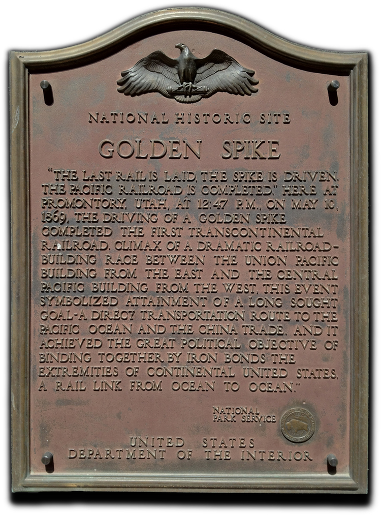 “Golden Spike” Site Monument Bronze Plaque - From the concrete obelisk built by the Southern Pacific Railroad to commemorate joining of the rails. The original granite plaque read, “Last Spike Completing First Transcontinental Railroad Driven at this Point May 10 - 1869.” The recessed granite plaque was covered with concrete and this bronze plaque placed over the original plaque. Click on the image to open a web page showing the obelisk and details regarding its significance.
[5/22/2012] © Copyright 2012, ChasingSteel.com. All rights reserved.
;) NPS Park Ranger David Kilton delivers a fact-filled, yet entertaining, presentation on the building of the transcontinental railroad and the Golden Spike Ceremony at the spot were the last rail was laid while Central Pacific’s locomotive “Jupiter” waits to do a photo runby.
NPS Park Ranger David Kilton delivers a fact-filled, yet entertaining, presentation on the building of the transcontinental railroad and the Golden Spike Ceremony at the spot were the last rail was laid while Central Pacific’s locomotive “Jupiter” waits to do a photo runby.
[5/22/2012] © Copyright 2012, ChasingSteel.com. All rights reserved.
;) Jupiter Prepares for Runby at Promontory - Central Pacific’s locomotive “Jupiter” makes a reverse move prior to doing a photo runby.
Jupiter Prepares for Runby at Promontory - Central Pacific’s locomotive “Jupiter” makes a reverse move prior to doing a photo runby.
[5/22/2012] © Copyright 2012, ChasingSteel.com. All rights reserved.
;)
;) Engine Crew at Promontory - The attention to historical accuracy is maintained in the garb worn by the engine crews at the Golden Spike National Historic Site.
Engine Crew at Promontory - The attention to historical accuracy is maintained in the garb worn by the engine crews at the Golden Spike National Historic Site.
[5/22/2012] © Copyright 2012, ChasingSteel.com. All rights reserved.
;) Union Pacific’s No. 119 Prepares for Runby at Promontory - Union Pacific’s locomotive “No. 119” begins a reverse move prior to doing a photo runby.
Union Pacific’s No. 119 Prepares for Runby at Promontory - Union Pacific’s locomotive “No. 119” begins a reverse move prior to doing a photo runby.
[5/22/2012] © Copyright 2012, ChasingSteel.com. All rights reserved.
;) Union Pacific’s No. 119 Photo Runby at Promontory - Union Pacific’s locomotive “No. 119” performs a photo runby on the siding at Golden Spike NHS.
Union Pacific’s No. 119 Photo Runby at Promontory - Union Pacific’s locomotive “No. 119” performs a photo runby on the siding at Golden Spike NHS.
[5/22/2012] © Copyright 2012, ChasingSteel.com. All rights reserved.
;)
;) Replica Engines at Promontory - The attention to historical accuracy is maintained by these identical replica steam engines of the original locomotives which were present during the Golden Spike Ceremony.
Replica Engines at Promontory - The attention to historical accuracy is maintained by these identical replica steam engines of the original locomotives which were present during the Golden Spike Ceremony.
[5/22/2012] © Copyright 2012, ChasingSteel.com. All rights reserved.
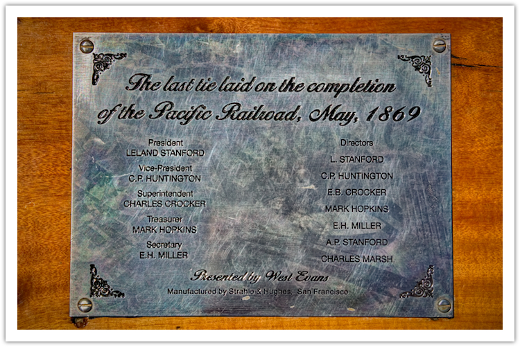 Plaque on the Last Tie - A replica tie sits in place of the original last tie laid and it is adorned with this plaque.
[5/22/2012] © Copyright 2012, ChasingSteel.com. All rights reserved.
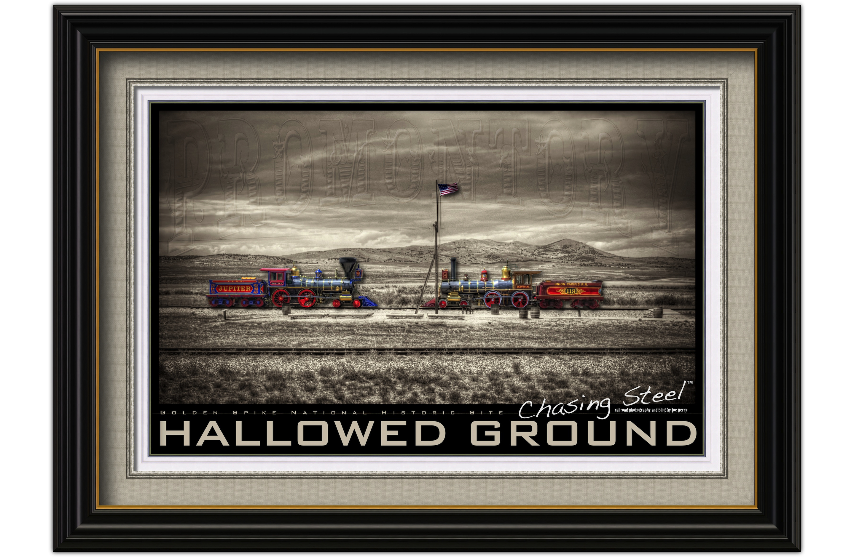 Hallowed Ground - No. 119 and Jupiter stand where giants once stood at the Golden Spike National Historic Site.
(I consider this my piece de resistance from my visit to the Golden Spike National Historic Site and it is one of my favorite works that I have done thusfar.)
[5/22/2012] © Copyright 2012, ChasingSteel.com. All rights reserved.
More to See and Do
Besides the photo runbys or steam engine demonstrations there are many things to do during your visit to the site. There is a Visitor’s Center with a gift/book store, a theater, and a small exhibit space. Plans are currently underway to update and improve the exhibits and static displays. Also there are some great outdoor activities as well as this excerpt from the Golden Spike National Historic Site web site explains:
Reenactment Ceremony
Step back in time to join Leland Stanford, Thomas Durant, and others to relive one of our nation’s significant events. Reenactments of the “Golden Spike” ceremony are held on Saturdays and holidays between May 1st and Labor Day at 11:00 a.m. and 1:30 p.m., at trackside in front of the locomotives, the same location where the original ceremony was held over 142 years ago on May 10, 1869.
Big Fill Loop Trail
This is a mile and a half round-trip walking trail. You will be walking out on original Central Pacific grade and back on the Union Pacific grade. The trail allows you to see and even walk out on the Central Pacific’s Big Fill. Walk through cuts, over fills, and see drill marks where workers blasted rock away. Keep in mind, all of this was accomplished by simple tools, sweat, and an amazing amount of endurance.
Promontory Auto Tours*
See evidence of construction methods used to build the railroad along two tours in Golden Spike National Historic Site.
The West Auto Tour is a 14-mile loop drive. As you ride on the original Central Pacific grade, look for the Union Pacific parallel grade; pass through several cuts; view fills, a stair-step cut, rock and wood culverts, and a distant glimpse of the Great Salt Lake. Pass the spot where the Central Pacific workers laid 10 miles of track in one day. The West Auto Tour closes in the Winter season.
The East Auto Tour is a 2-mile drive. Along the way, see the Union Pacific’s last cut; several trestle abutments and fills; drive through cuts made by blasting rock; and walk to the Chinese Arch, a natural limestone formation, a memorial to the thousands of Chinese who helped build the Transcontinental Railroad. Descend the steepest mile of railroad grade in Utah as you leave the tour. The East Auto Tour’s hours are 9:00 a.m. to 4:30 p.m. in the Winter season. In bad weather or heavy snowfall, the East Auto Tour may close.
A Hearty Thanks and If You Are Ever in Northern Utah…
I truly enjoy visiting this site each and every time I go there. I am thankful to all of the men and women of the National Park Service and the volunteers that keep this site alive and available for us all to enjoy. I look forward to seeing the site in the future as it gets even better year after year. I highly recommend that you stop by and see the magic of Promontory for yourself and step back in time to a nondescript place with tremendous significance in America’s story.
Fellow Travelers and Bloggers
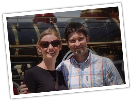 Sierra and Cameron from allinanairstream.com.
While I was inside the Visitor’s Center, pouring through the vast amount of books that were on sale, Deb was still taking some shots outside near the locomotives.
While doing this she met a young couple, Cameron and Sierra, who were also taking photos of the engines. It turned out that they too are bloggers and were at Promontory as part of a road trip of their own.
They run a web site/blog called All In An Airstream.com and you should go check out Cameron’s photos.
 Events, General Photography, Railroad Photography, Ramblings and Such